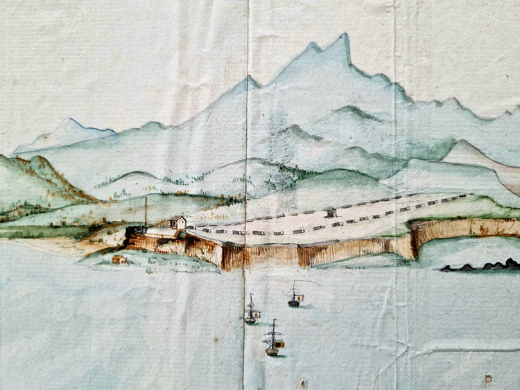
Frederici, Prospect van het eyland, en de rheede van St. Iago, 1783.
- Regular price
- €0,00 EUR
- Regular price
-
- Sale price
- €0,00 EUR
- Unit price
- per
Large VOC watercolour view of Porto Praia, Cape Verde
Johann Christian Friderici [= Frederici] (Heldburg 1766 - Cape Town 1804).
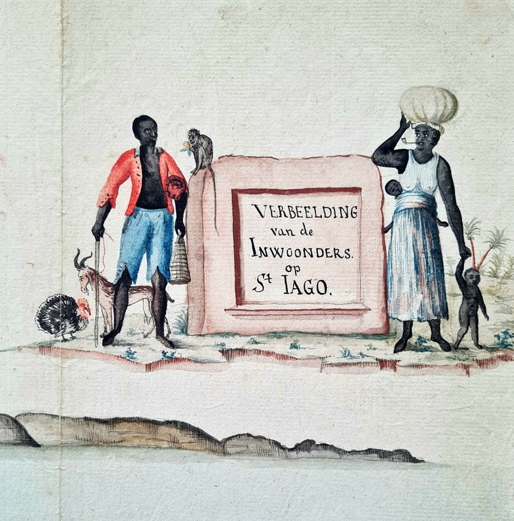
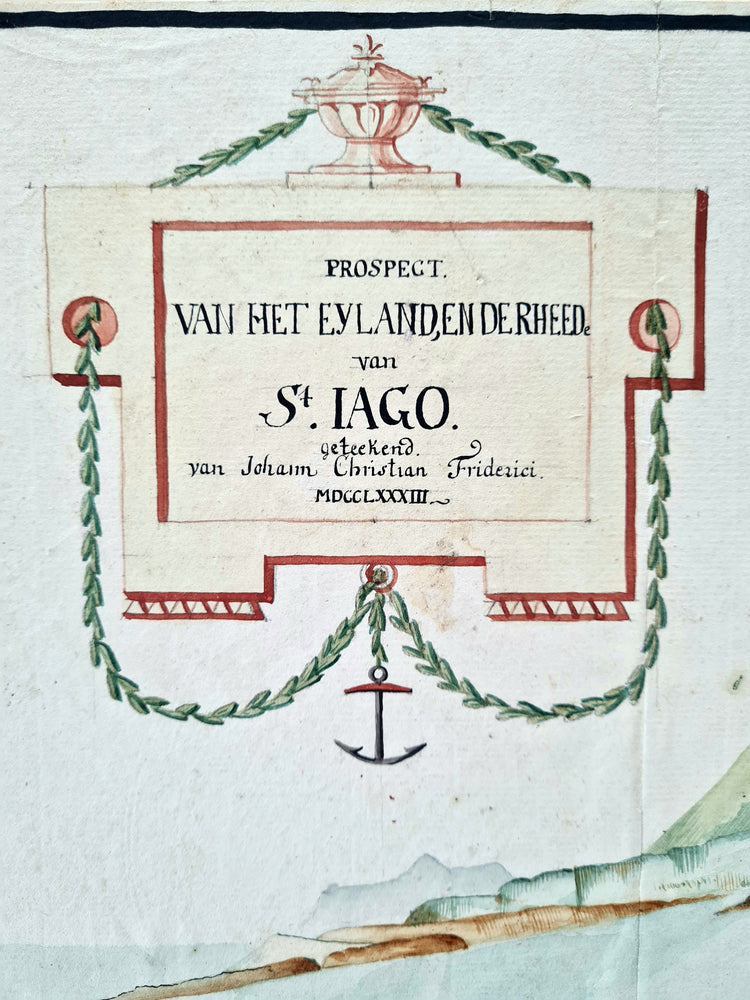
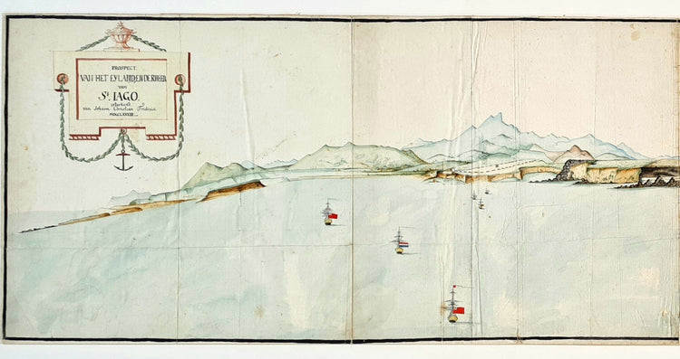
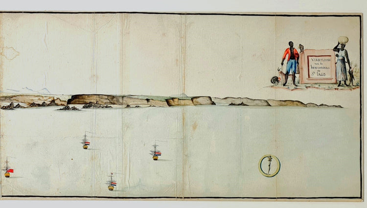
Prospect van het eyland, en de rheede van St. Iago. Geteekend van Johann Christian Friderici / Verbeelding van de inwoonders op St Iago.
Porto Praia, Cape Verde, 1783.
Watercolour with ruled black ink border on laid paper, watermarked Pro Patria with Maid of Dort. 29,5 x 120,5 cm.
The largest recorded early modern panoramic view of Cape Verde, by “the best VOC map maker in South Africa” (Koeman). This is his earliest known work.
Santiago’s Porto Praia is the main harbour of Cape Verde. It served as an important transportation hub of enslaved African people to the Americas and for the restocking of ships bound for the Cape with salt and fresh foods. These two functions of the island are depicted in the cartouche in the top right. It shows an African family and examples of livestock: a turkey and a goat. The man wears clothes that are also seen in depictions of plantation guards in the West Indies of the same time. The artist of this exceptional drawing has depicted the southern coast of the island in its full length but at an interesting angle, which causes the harbour to be hidden from view. Instead, the center of attention is a farm. He also added a mixed fleet of British and Dutch ships peacefully together. Although at the time of the drawing (1783) these two nations were at war (the Fourth Anglo-Dutch War, 1780-1784), in reality British and Dutch ships were coming together without conflict since 1782. In 1781 Porto Praia was the scene of a large naval battle between the British and the French. The stake of the battle was access to the Cape Colony that was still under Dutch control. The French, allies of the Dutch, managed to stall the British, though eventually the Cape was lost by the Dutch and this set about the decline of The Netherlands as a colonial empire. Regarding the position of Frederici’s drawing in the cartographic history of Porto Praia, nothing compares in size, detail and quality. We traced no record of this drawing in literature: it is not included in A. Teixeira da Mota’s history of the cartography of Cape Verde: Cinco seculos de cartografia das ilhas de Cabo Verde (1961, estampa IX), nor in the Dutch National Archive’s monumental Grote Atlas van de Verenigde Oost-Indische Compagnie. Both have included several other Porto Praia views. The most influential early modern panorama view of Porto Praia is a 1772 engraving by Fleurieu after a lost drawing by Manevillete from 1763, titled Vue de la rade de la Praya dans l’ile de Saint-yago. This panorama was published in several atlases throughout the late 18th century. Frederici’s drawing shows the same area, but it is certainly not a copy. It has a slightly more east angle and the drawing is much more detailed and of higher quality in general than Fleurieu’s engraving. We also traced a watercolour view of St. Iago by James Forbes (1773-1861): Natives of St. Iago / A view of Porto Praya at the Island of St. Jago [1765]. 45 x 29cm. Biblioteca Nacional (Brasil). “Manuscript upon Brazil”, p. Vista 02. This drawing also has a cartouche with local inhabitants.
Everything we know about Johann Christian Frederici is from his time in the Cape of South Africa, where he made several extraordinarily important maps, including, according to Cornelis Koeman, “the best map dating from the eighteenth and beginning of the nineteenth centuries of the south coast of the Cape Colony known to us”. This is the Caerte van den Zuydelijken oever van Afrika (Nationaal Archief, 4, TOPO 15 11), in which he was helped by VOC bombardier Josephus Jones. The earliest dated work known by Frederici up to now is from 1788: Kaart van de westkust tussen Saldanhabaai en Tafelbaai (Rijksmuseum RP-T-1914-17-6), a more than 3 meters wide map of the Cape Colony area. The date 1783 of the present Porto Praia view makes it by far Frederici’s earliest recorded work and the only one that does not depict a part of South Africa. Frederici was administered as a German immigrant into South Africa in 1784, just after the date of the St. Iago panorama, indicating that he probably made the drawing when he was sailing with the VOC from The Netherlands to South Africa. Once he arrived in the Cape he was first employed by Cape Governor Van der Graaff as a military surveyor. The Grote Atlas mentions Frederici (as Friderici) as a VOC cartographer in South Africa since 1789 and assistant of cartographer J.W. Wernich. Wernich was German, which might explain why the maps that Frederici made in that period are in German, and the present panorama drawing is in Dutch. In 1791 he became Lieutenant in the Cape Artillery. In this position he made many impressive maps of the Cape which are now kept in the Dutch National Archives, the Rijksmuseum, the British National Archives and the South African Library of Parliament. The latter holds an invaluable view of the Battle of Muizenberg (1795) by Frederici as well. He is also the maker of some very large maps in the famous Gordon Atlas (also Rijksmuseum), some signed by him and others attributed to him. The Frederici/Friderici (or Frederici, Frideric, Fredericie etc.) family name is found amongst military servicemen employed by the VOC since the mid-17tcentury. There were a number of Frederici/ Friderici families living in the Cape in the late 18th century, all were from different parts of Germany, enrolled into the Dutch East India Company and settled in the Cape. Most notable is the family of Joachim de Frederici, who moved from the Cape to Surinam in 1762, where his son Juriaen François Friderici become Governor-General.
Condition: pasted on support and flattened, numerous old folds with some splitting and small repairs, minor damp-stains, pinholes and surface dirt.
Literature:
Avelino Teixeira da Mota, Cinco seculos de cartografia das ilhas de Cabo Verde. Junta de investigações do ultramar, 1961.
Bea Brommer a.o., Grote atlas van de Verenigde Oost-Indische Compagnie = Comprehensive atlas of the Dutch United East India Company. Vol. V: Afrika. Voorburg, Asia Maior/Atlas Maior, 2009: “Friderici [sic], Johan(n) Christia(a)n (1789[sic]-1791), bombardier, luitenant, kaartenmaker, assisteerde in 1791 de landmeter J.W. Wernich.”
Cornelis Koeman, “Beschrijving van een belangrijke 18e eeuwse manuscriptkaart van de Kaapkolonie”, in: Africana Notes and News 11(7), pp. 276-287.
Cornelis Koeman, “landmeters in dienst van de VOC in de Kaapkolonie”. In: Tijdschrift voor kadaster en landmeetkunde (1952), pp. 93-96.
Elri Liebenberg, “Unveiling the geography of the Cape of Good Hope: selected VOC maps of the interior of South Africa”. In: History of Cartography (2010), pp. 209-232.
Miele Dirk Haga, Een beeld van een land : Zuid-Afrika gezien door R.J. Gordon, tussen 1773 en 1795 / [Tekst M.D. Haga], Amsterdam, Rijksmuseum, 1995.
Couldn't load pickup availability
Share

Contact
Email: hugo@artemrarebooks.com
Phone: +31651042297
Visit us on appointment at:
Former US Embassy
Lange Voorhout 102
2514EJ
The Hague (The Netherlands)
Shipping address:
Nannie van Wehlstraat 51
2548MN
The Hague
The Netherlands


